


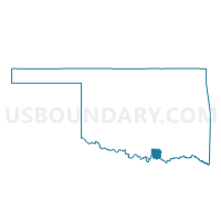
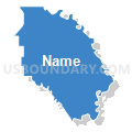
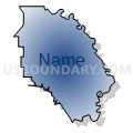
Voting District 206, Marshall County, Oklahoma
About
Outline

Summary
| Unique Area Identifier | 654433 |
| Name | Voting District 206 |
| County | Marshall County |
| State | Oklahoma |
| Area (square miles) | 67.24 |
| Land Area (square miles) | 59.92 |
| Water Area (square miles) | 7.32 |
| % of Land Area | 89.11 |
| % of Water Area | 10.89 |
| Latitude of the Internal Point | 34.10005900 |
| Longtitude of the Internal Point | -96.62758660 |
Maps


Graphs
Select a template below for downloading or customizing gragh for Voting District 206, Marshall County, Oklahoma


Neighbors
Neighoring Voting District (by Name) Neighboring Voting District on the Map
- Voting District 13, Johnston County, OK
- Voting District 2, Johnston County, OK
- Voting District 201, Marshall County, OK
- Voting District 204, Marshall County, OK
- Voting District 25, Bryan County, OK
- Voting District 28, Bryan County, OK
- Voting District 3, Johnston County, OK
Top 10 Neighboring County Subdivision (by Population) Neighboring County Subdivision on the Map
- Durant CCD, Bryan County, OK (28,719)
- North Marshall CCD, Marshall County, OK (8,588)
- Tishomingo CCD, Johnston County, OK (5,178)
- East Johnston CCD, Johnston County, OK (3,079)
Top 10 Neighboring Unified School District (by Population) Neighboring Unified School District on the Map
- Madill Public Schools, OK (8,627)
- Kingston Public Schools, OK (7,213)
- Silo Public Schools, OK (6,681)
- Tishomingo Public Schools, OK (4,673)
Top 10 Neighboring State Legislative District Lower Chamber (by Population) Neighboring State Legislative District Lower Chamber on the Map
- State House District 21, OK (39,709)
- State House District 49, OK (38,581)
- State House District 20, OK (35,429)
Top 10 Neighboring State Legislative District Upper Chamber (by Population) Neighboring State Legislative District Upper Chamber on the Map
Top 10 Neighboring 111th Congressional District (by Population) Neighboring 111th Congressional District on the Map
Top 10 Neighboring Census Tract (by Population) Neighboring Census Tract on the Map
- Census Tract 7960.01, Bryan County, OK (5,728)
- Census Tract 6602, Johnston County, OK (5,178)
- Census Tract 946.98, Marshall County, OK (3,734)
- Census Tract 6601.98, Johnston County, OK (3,079)